
Logan ZIP Codes and Their Labels
The Utah ZIP list associates Logan with 84321, 84322, 84323, and 84341. That is the postal city pairing recorded by the state list. It is not a street-by-street boundary file, a city-limits layer, or a count of Logan residents. The list also pairs nearby Cache communities with their own ZIP values, so a Logan mailing line should be checked rather than guessed from a neighboring label.
| Postal code | Postal city label | What the list supports | Important caution |
|---|---|---|---|
| 84321 | Logan | Logan postal pairing | Confirm delivery address and municipality |
| 84322 | Logan | Logan postal pairing | ZIP is not a resident list |
| 84323 | Logan | Logan postal pairing | Use current USPS data for delivery |
| 84341 | Logan | Logan label in the state list | North Logan office context can appear |
The state list is the lead source for a Logan postal directory, while the Utah ZIP-area GIS page explains that postal areas serve delivery and include approximate ZIP-area and PO-box layers. Polygons can change, so keep the map date with any boundary statement.
The state ZIP list is the clearest fallback if the shorter Utah ZIP lookup URL does not resolve.
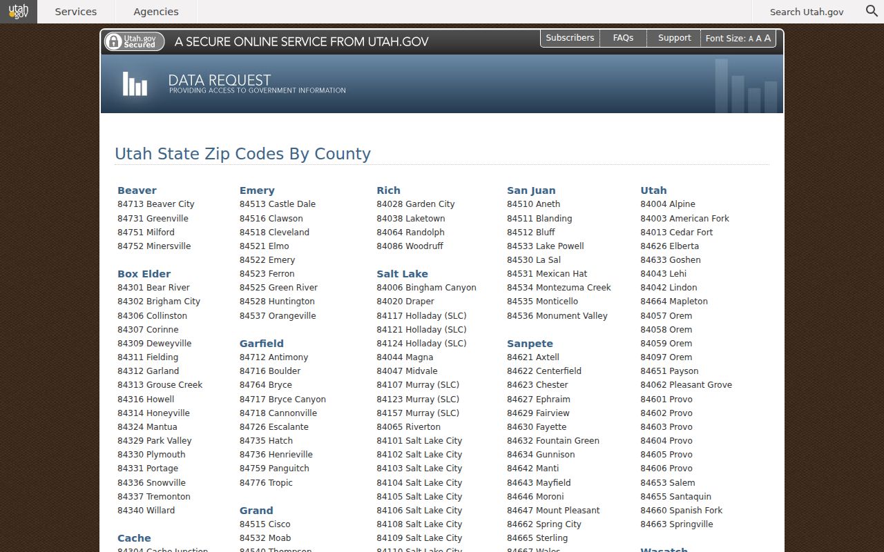
The capture shows why the four Logan labels should be read as postal data and then checked against USPS and Cache GIS.
Finding Logan Residents by Postal Code
A ZIP filter is a narrowing step, not proof of residence. Begin with the name, address, or parcel clue. Confirm the mailing format through the USPS AIS Viewer. Then compare the ZIP against the Cache parcel viewer or CORE. If the question concerns public registration, use the election office’s lawful route and omit protected voter fields. If it concerns history, a ZIP may help find a book or map but will not replace the edition year.
- Write down the exact postal code and postal city as supplied by the address holder.
- Check the address and delivery type in USPS AIS.
- Use Cache GIS or CORE to see the parcel, situs line, tax ID, and municipality.
- Run only the record search that fits the purpose, such as a property, voter, or business dataset.
- For street-level work after the ZIP is narrowed, use the Logan by-street address route.
Utah’s state building-permit list can accept ZIP code filters along with original permit and state-received dates. Its results may include a property address, permit number, issuing municipality, owner or contractor fields, and estimated project cost. Local submissions can be incomplete or two to four weeks delayed. A ZIP-wide result is not a current household directory.
ZIP Code Versus Logan City Limits
Postal geography and municipal geography overlap, but they answer different questions. Logan, North Logan, Providence, River Heights, Hyde Park, and other Cache places can sit near one another while an address uses a Logan postal label. The state ZIP list does not decide which city issued a permit. Current Cache GIS and Logan municipal maps, plus the issuing office, do that work.
- ZIP versus ZIP+4
- A ZIP code names a delivery area; ZIP+4 adds a smaller delivery segment. Neither is a city-limit boundary.
- PO-box ZIP
- A postal designation for box delivery that may not locate a home parcel.
- Unique ZIP
- A code assigned to one large organization or special delivery group.
- Carrier route
- A postal delivery path inside a ZIP area, not a public resident roster.
The Utah Open Data history records an adjustment and improvement to 84321 and 84341 boundaries in November 2014. That matters when a historical address or old record is compared with a modern map. Do not silently rewrite an old ZIP into today’s line.
USPS Offices Behind Logan ZIP Data
The research uses the Logan post office at 75 W 200 N, Logan, UT 84321, and the North Logan office at 1721 N 400 E, Logan, UT 84341, as office examples. An office address does not establish every delivery boundary. USPS AIS is the better check for an exact mailing address, city, state, and delivery type. Support is listed at 800-238-3150.
The 2003 postal archive places Logan 84321–84323 in an older scheme. It is useful historical context, not a current ZIP code directory. Current delivery questions belong with AIS, while a dated address question may need the archived scheme, an old directory, and a map from the same time.
Note: A ZIP code is a routing label, so use Cache parcel geography when the question is about land or municipal records.
ZIP Filters in Cache Property Records
CORE’s public form does not function as a simple ZIP directory. It searches Tax Year, Parcel, name, House Number, Street, City, and Legal Description. Cache GIS can search a tax ID or address and show a card with owner, mailing address, property address, tax district, zoning, acreage, year built, and legal description. The mailing ZIP can help compare records, but it remains a correspondence field.
| Source field | Use | Limit |
|---|---|---|
| Mailing ZIP | Compare a tax correspondence address | Not proof of occupancy |
| Property / situs address | Locate the mapped parcel | Not a resident name |
| Tax ID | Join CORE, GIS, and Property Watch | Does not unlock protected records |
| City field | Narrow a public CORE query | Postal city can differ from municipality |
The GIS viewer is moving from Web AppBuilder to Experience Builder. The county notice plans legacy maintenance in Q4 2026 and targets retirement in Q2 2027. Record the interface date when a ZIP boundary or parcel card is saved.
Voter and Business ZIP Searches
Utah voter data can include a registration address, county, district, party, status, last update, and vote history in a statewide file. The research lists a current statewide file fee of $1,050 and tab-delimited delivery of about 150 MB, with email delivery within one business day. A who-voted report is listed at $35 per election. Those are administration data routes, not a downloadable Logan contact list. At-Risk records are excluded or anonymized, and protected fields stay closed.
Utah’s business list accepts ZIP, entity type, NAICS, registration and expiration dates, and status. It can return entity and filing roles, but a registered agent or principal address is not proof of a person’s home. A credential or business result is not a resident match. Keep ZIP geography tied to the record’s stated purpose.
Historical ZIP Changes in Logan
A past directory, map, or voter record may use a ZIP that no longer follows the same polygon. The 2014 adjustment to 84321 and 84341 is a documented example. Earlier postal material places 84321–84323 in a 2003 scheme. When an old record looks inconsistent, preserve its original ZIP and date, then test the current address through AIS and Utah ZIP-area GIS.
Historical Logan city directories observed from 1913–14 through 1988 generally organize entries by name, street, or phone rather than by today’s ZIP. Sanborn maps from 1900 and 1930 show block context without postal boundaries. The ZIP code directory is therefore strongest for present postal routing and carefully dated comparisons, not for back-projecting every old address.
ZIP Code Directory Limits
A match on 84321, 84322, 84323, or 84341 narrows a search but does not prove that a person lives in Logan. It cannot establish ownership, a city boundary, a current household, or access to a protected voter or vital record. It may also describe a PO box, business, or mailing address.
Four-way check. Keep postal city, delivery ZIP, parcel municipality, and record custodian as separate fields. If they disagree, verify the address rather than forcing them into one Logan label.
Use a narrow official source, preserve its retrieval date, and ask the custodian when a copy or correction is needed. A ZIP code directory is helpful when it points to the right next record. It is not a substitute for that record.