
How to Find Logan Residents
There is no single public book for every person in Logan. The useful path depends on the question. For a parcel question, begin with Cache County CORE and then compare the map card in the Cache GIS parcel viewer. For civic registration, use the Cache County election office and the statewide Utah voter-data rules. For an older household, the Utah City Directories collection and Logan Library are better starting points than a current portal.
Use the result as dated evidence, not as a claim about a person’s present home. An owner field, a mailing address, a property address, a voter registration address, and a historical directory entry describe different things. A name match should have a second point of support, such as a parcel number, court jurisdiction, year, or street. Keep the search narrow and use the office that created the record when a copy, correction, or protected detail is needed.
- Write down the name, street spelling, ZIP, parcel clue, and time period.
- Confirm that the address is in Logan or another Cache municipality, rather than relying on a postal city label.
- Use CORE or GIS for parcel context, then read the Recorder index or request a document copy.
- Compare lawful public voter, court, business, or vital sources only when they fit the research purpose.
- Move to Logan Library, Utah Archives, or a specific GRAMA request when the online trail ends.
Logan Resident Records Offices
Cache County offices surround the Logan record trail. The Cache County Recorder keeps land-title documents and an index, makes recorded documents open for inspection, and maintains ownership plats. The Assessor supplies tax context and property characteristics. The Clerk handles elections, licenses, annexation material, council records, and GRAMA routing. Logan’s own city records belong with the Logan Records Officer, not automatically with a county office.
Recorder staff can help locate a parcel or document in the vault or CORE, but they do not prepare documents, give title or boundary advice, perform a title search, or promise that old pages are digitally indexed. For a Logan city record, the city code directs a written request to the applicable Records Officer by mail, hand delivery, or electronic delivery. Name the record and date with enough detail for staff to find it.
CORE Parcel Search Fields for Logan
The county’s public parcel search is the most direct Logan property starting point observed in the research. Its public search accepts a Tax Year, Parcel, Last Name or Business Name, First Name, House Number, Street, City, and Legal Description. Fields marked with an asterisk support partial matching. The form does not require every field, so a street or parcel prefix can narrow a first pass. The examples include E 100 N in Logan, a parcel prefix such as 01-001, and Fish & Game parcels.
| CORE field | Use in a Logan search |
|---|---|
| Tax Year | Choose the assessment year shown by the public form. |
| Parcel | Try a known tax ID or a partial parcel prefix. |
| Name fields | Search a last or business name, with an optional first name. |
| House Number / Street / City | Test an address, such as a Logan street, without assuming it proves occupancy. |
| Legal Description | Use a deed or parcel phrase when the street address is unclear. |
The public tier is listed as $0 per month with a 100-parcel-per-day limit and basic tax information. A subscriber label observed in the research lists $80 per month for unlimited searches, images, and abstracts. Bulk or custom results use a separate request and variable fee. CORE calls public data representational, not authoritative. Confirm current pricing and use the Recorder for a certified or regular copy.
Note: A CORE match is a parcel lead, so compare its tax year, map location, and legal description with the source office.
- Parcel
- A county property unit identified by a tax number and mapped boundaries.
- Roll
- A record list maintained for a defined purpose, such as assessment or voter registration.
- Index
- A finding aid for records, not necessarily the full document image or a title opinion.
A Logan Address Has Two Identities
Cache valuation notices and GIS cards separate the mailing address from the property, or situs, address. The mailing line is where tax correspondence goes. The situs line identifies the mapped place being assessed. Those lines can differ without either one being wrong. A ZIP is a postal routing label, while a legal description belongs to the parcel or deed. Read each field in its own setting before carrying it into a Logan residents directory search.
| Field | What it means | What it cannot prove |
|---|---|---|
| Mailing address | Tax or owner correspondence destination | That the owner lives there |
| Property / situs address | Mapped place tied to the parcel | Who occupies the building |
| ZIP code | Postal delivery area | Logan city limits or a resident |
| Legal description | Parcel or deed description | A simple street address by itself |
The GIS sample card uses parcel 06-019-0009 and displays separate owner, mailing, property address, tax district, zoning, acreage, year-built, and legal-description fields. It is a field example, not a statement about every Logan parcel. Map layers can change, and the county is moving from ArcGIS Web AppBuilder to Experience Builder. The county notice says legacy maintenance is planned for Q4 2026 and retirement is targeted for Q2 2027.
Current Logan Resident Records by Source
Current directory work is a chain of records rather than a roster that can be copied into one list. The source determines what the name means and what the public may see. The voter roll can show a registration address and age range under Utah rules, while the property roll centers on ownership or tax data. Court, license, and business records confirm a case or credential, not a person’s identity as a Logan resident.
| Source | Useful signal | Custodian and access |
|---|---|---|
| CORE / Assessor | Parcel, owner field, tax year, mailing and situs fields | Cache County, public search with limits |
| Recorder index | Recorded parties, plats, entry and document context | Cache Recorder, inspection or copy route |
| Voter information | Name, address, age range, party and vote history where public | Cache Clerk and Utah election sources, protected fields withheld |
| Court index | Party, case, filing events and disposition context | Utah Xchange, billable or free courthouse terminal |
| License or entity file | Credential, business role, status, or filing address | Utah DOPL or business list, role-specific |
When the goal becomes one named person, use the Logan resident lookup workflow. When the goal becomes a whole street, use the address method in the Logan by-street directory. That division keeps a historical listing, a tax field, and a court party from being presented as the same kind of evidence.
Cache GIS Layers for Logan Property Research
The Cache GIS map menu adds context around a parcel. The inspected layer list includes parcels and zoning, voting and precinct information, floodplain, surveys and section corners, original 1800s surveys, historical roads and parcels, 1974 aerial imagery, development by decade, and a house-number map generator. GIS can show how a street or parcel sits in a larger pattern. It is a map aid, not a title opinion.
Use the address or tax ID search, then zoom and pan to check the location. Compare the card’s legal description with CORE and a recorded instrument before making a claim about ownership. Historical roads and parcel layers are useful when an old street name does not match a current address. A visible line on a map does not by itself establish a current boundary, occupant, or legal right.
Note: Cache GIS coordinates Assessor, Recorder, Clerk, and Treasurer data, so a layer’s date and source still matter.
What Utah Voter Records Reveal in Logan
Cache County directs registration and updates through its election office and Vote.Utah.gov. The county route accepts mail, email, or in-person delivery at 179 N Main, Suite 102, Logan, and the county says the deadline is 5 p.m. 11 days before an election. The Utah form asks for legal name, physical and mailing address, date of birth, identification, party choice, prior address, privacy choices, and signature. Most of those fields are not public directory material.
Utah’s public voter list can include a name, physical or mailing address, age range, party affiliation, and vote history. Vote history means participation in named elections, not a candidate choice. Date of birth, driver-license or state-ID number, Social Security number, email, phone, and signature are protected. At-Risk records can be withheld or anonymized. Safe at Home participants use a substitute address, so a public address result should never be used to defeat that protection.
Cache Property Watch Alerts
Cache County Property Watch is a distinct tool for a person with a legal or equitable interest in a Cache property. A signup can use a tax ID in the format shown by the county, or a first name with a last name, business, or trust. The service sends a free email after a qualifying document is recorded, processed, and verified against the selected property.
An alert may be months or years apart. No alert does not mean no ownership change, no document, or no fraud. A notice is a prompt to inspect the official document. Property Watch is Cache-only, subscriber identity is not disclosed, and the program can end after ownership changes or withdrawal. Use the Recorder, not the alert email alone, when a deed or copy is needed.
Research boundary. A public record supports a lawful, narrow question. It is not an invitation to publish a private address, contact a stranger repeatedly, or map a protected person.
Logan Planning Areas and Neighborhood Geography
Logan’s parks, trails, recreation, and open-space plan groups the city into six planning areas organized around Logan City School District elementary-school geography: Adams, Bridger, Ellis, Hillcrest, Wilson, and Woodruff. Adams received a neighborhood-specific plan in 2012. These are planning geographies shaped by land use, transportation, parks, environmental sensitivity, and community input. They are not proof that six current neighborhood associations maintain resident rosters.
| Planning area | Research use |
|---|---|
| Adams | Named planning area; a 2012 neighborhood plan is noted. |
| Bridger | Named planning geography in the city plan. |
| Ellis | Named planning geography in the city plan. |
| Hillcrest | Named planning geography in the city plan. |
| Wilson | Named planning geography in the city plan. |
| Woodruff | Named planning geography in the city plan. |
The research located no official current umbrella directory for associations in these areas. Use the city plan for planning context, and ask a verified organization or city office about a current meeting or membership question. Do not turn a planning label into a claim about who lives in that area.
Historical Logan Resident Directories
The Utah City Directories collection holds Logan titles observed from 1913–14 through 1988, with gaps rather than a complete annual run. The 1974 R.L. Polk volume has a classified business section, alphabetical directory, street directory of householders and businesses, numerical telephone directory, and advertisements. A 1915–16 item is a 226-page scan with a page-15 view. These books can show a name, street, occupation, business category, or phone entry as printed in that year.
Logan Library is the local access point listed at 285 N Main, Logan, with a reference number of 435-716-9123 and hours shown as Monday through Thursday 10–9, Friday 10–6, and Saturday 1–6. The dated house-history guide also points to newspapers, census material, Sanborn maps, permits, old appraisals, and deeds. A directory entry is historical evidence, not a current address. The dedicated Logan city directories collection page explains how to trace a household across years.
Logan’s 1900 Map and 1930 Blocks
The Library of Congress Logan Sanborn set contains 19 sheets from September 1900. The USU collection also exposes a 1930 Logan sheet with streets and landmarks, including Wilson School and the Logan 7th Ward meeting house. Sanborn sheets describe block and building context, including material colors that distinguish frame, brick, stone, iron, and adobe in the map legend.
Those maps answer what stood near a street in a particular year. They do not answer who owns the parcel today, who occupied it, or whether the building remains. Pair the historic sheet with a dated directory, current GIS geometry, and a Recorder document. Keep the map year visible whenever it is used in a Logan resident-history search.
Asking Logan Records Officers Under GRAMA
Utah’s Government Records Access and Management Act, or GRAMA, is the fallback when a needed Logan or Cache record is not exposed online. The request must be written to the agency that maintains the record. Include your name, address, phone if available, and a specific description. “All records about this address” is much harder to route than an incident report number, a permit application at an address on a named date, or a council record by meeting date.
- Identify the custodian: Logan City for a city record, Cache County for county property or Recorder material, or the state agency for a statewide dataset.
- Describe the record, date range, address, number, and format with reasonable specificity.
- Use the Utah Open Records Portal, email, fax, mail, or in-person route listed by the agency.
- Ask for a fee estimate. Utah materials describe actual-cost fees and a response framework of up to ten business days.
- Keep the response and fee decision. An appeal goes to the agency’s chief administrative officer within 30 days; Logan’s code points to the Mayor’s Office.
The request process does not erase exemptions. Voter, vital, court, Safe at Home, and safety-sensitive records each have separate limits. If a result could expose a survivor, victim, witness, juvenile, or protected address, stop at the custodian’s boundary.
Logan Record Portals at a Glance
The CORE public search is the parcel starting point for a Logan residents directory inquiry.
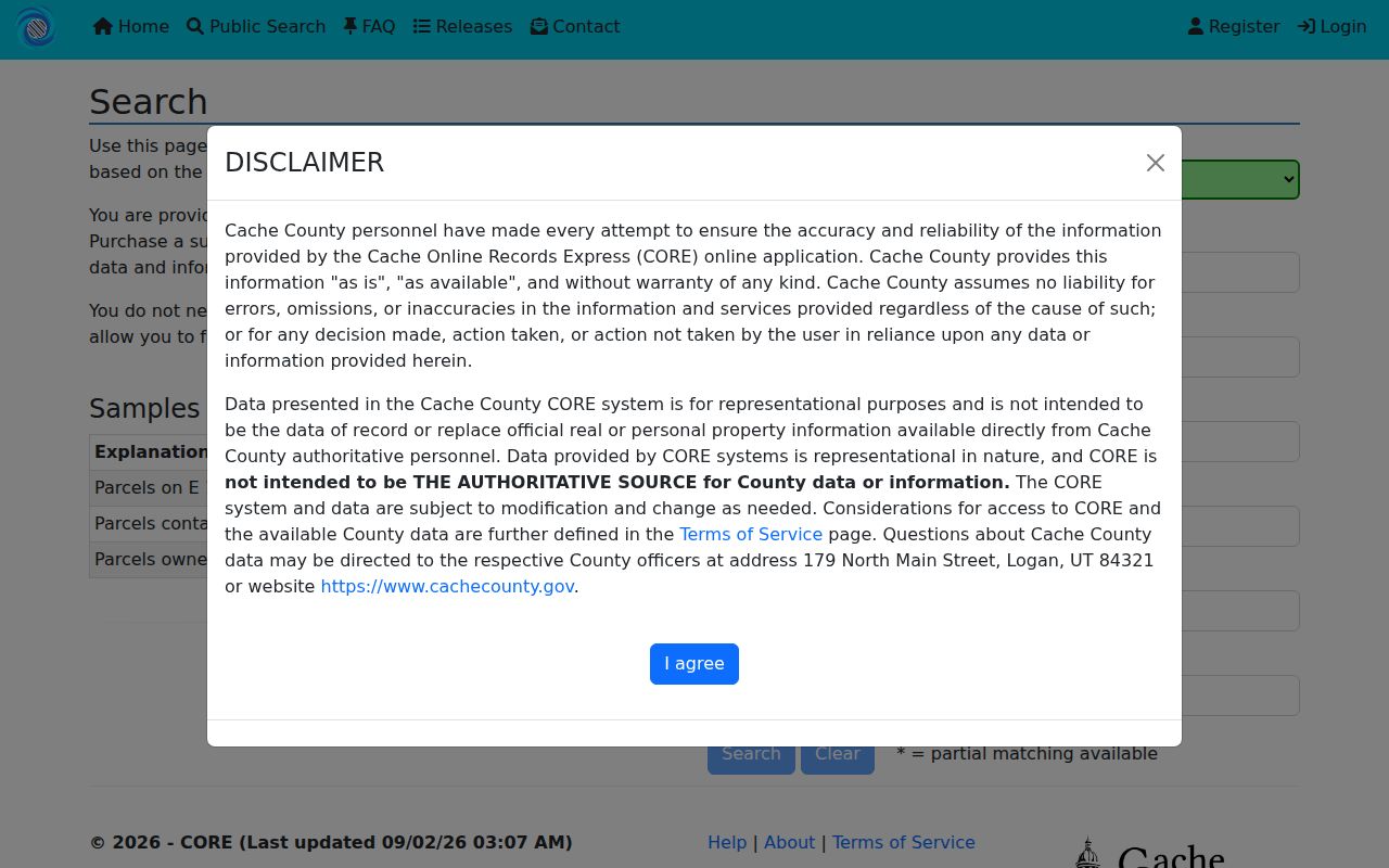
Its fields and daily ceiling belong beside the result, so a partial match is not mistaken for an authoritative title record.
The Cache GIS layer menu adds parcel, voting, historical road, survey, aerial, and development context.
Those layers help explain Logan geography, but a map remains a map aid and not a title opinion.
The Cache parcel viewer notice records the current move from Web AppBuilder to Experience Builder.
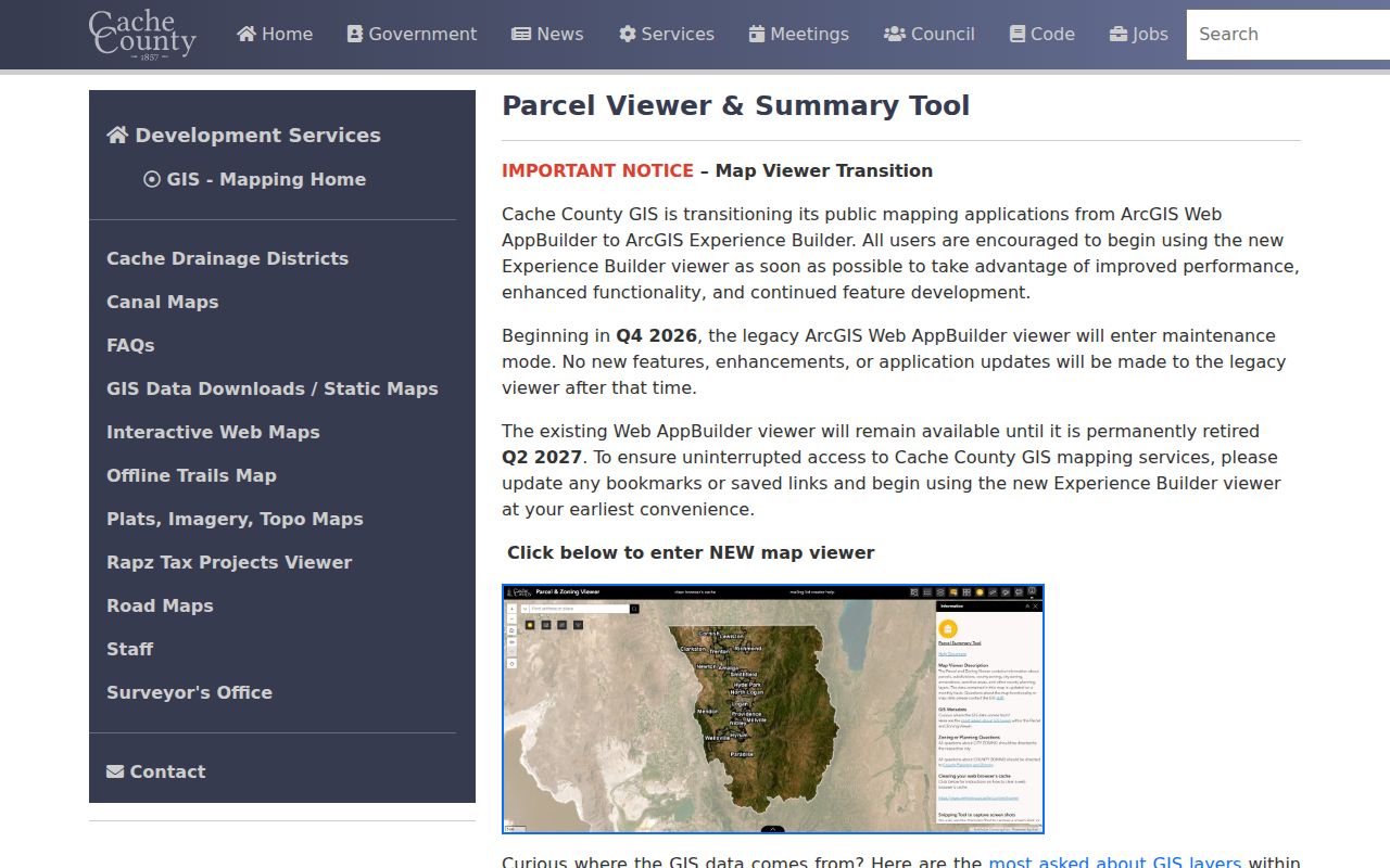
The transition is timely context for saving the retrieval date with a parcel card.
For a case question, Utah Xchange help shows the fields that narrow a Logan name.
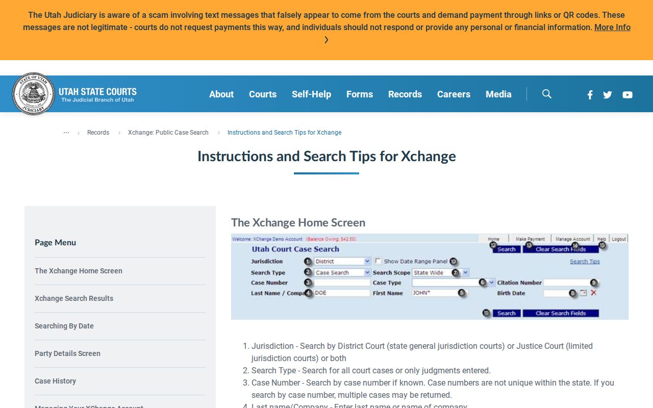
Xchange’s jurisdiction, case type, name, citation, and date controls make court research a separate workflow from parcel research.